A Cultural Resources Management (CRM) firm recently had a question about an old water-powered mill in our county. You don’t think much about water power in a state as flat as Florida, be we had lots of them. US 29, through Escambia County, could have been named “Industrial Boulevard” there were so many. The firm contacted the University and the query was forwarded until it got to me. I worked on the mill survey a couple of decades ago and am a go-to guy on mills and local history. That query led me to look into the history of the family that owned it. I discovered on a genealogy site that they had a cemetery and nobody knew where it was.
That struck me as a challenge, to find the cemetery. It was an exercise in armchair archaeology, followed by a trip to the field…a fun activity during lockdown, as I’d only be around dead people. I found dead people, thanks to Lidar topgraphy mapping.
There were depressions in the ground, indicating 3 graves. Genealogical reports indicated there should be 3 graves, dating from 1825 through 1849. The family had come here in 1819, when Pensacola was still a Spanish colony and they were prosperous planters.
The graves had been marked with wooden markers. I found bits of pine knots, but nothing that would indicate who was in which grave and I was curious about that. Could I properly determine, by non-invasive means, which person was where?
Mary Ann, the matriarch died first. Then her grandson John. Then John’s mom, Lucretia. I have dates of death for each and when I return I should be able to determine who is where!
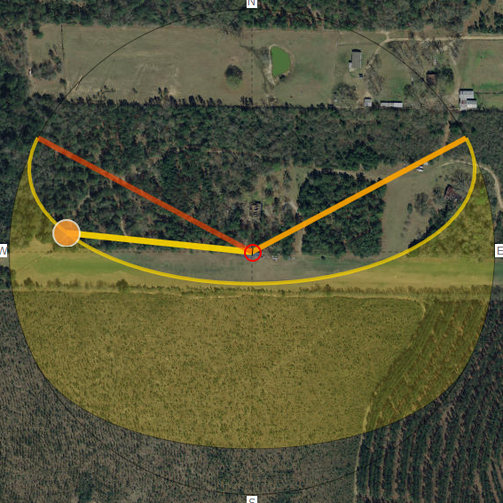
How, you ask? By the angle of the sun. Everybody knows the sun rises over there and sets over yonder, corresponding to some variation of east and west. Once you get a solar array, you start noticing a little more. For example, right now, in June, the first and last rays of the day are on the BACK of the Solar Shed! A fat lot of good that does. The sun isn’t moving in a straight line. It travels in an arc. In winter, that arc swings further to the south, beginning and ending closer to actual east and west. The nature of this arc will vary according to where you are.
Now back to cemeteries, most cultures will plant you in an east-west orientation. Modern cemeteries have very precise placement of graves, making things very compact and tidy. In the older cemeteries, sometimes charted using ground-penetrating radar, you’ll see some variation, with the direction of the feet swung a little to the north or south. That is because burials were aligned with the sun and not a compass. Therefore, I should be able to get the angle of the sunrise on a given date and match it to a particular grave. I think it is a pretty sure bet that Little John is between Mom and Grandma, so the real question will be who is on which end. I can’t wait to get back out there and take my measurements.
There are websites and apps that can calculate and display the sun’s arc for any particular time of the year, in case you would find such info handy.

But back to solar power, alignment of the solar panels can make a big difference in your power production and your best angles might be determined by how you use your power. Mine are pointed southward at roughly the same as my latitude, a general recommendation and they perform very well in the winter when the sun is lower and more southerly. I don’t use as much power in the winter because I have a wood furnace and do not use the heat pump. I could use the heat pump to save wood, but I have more wood than I can possibly use.
In the warmer months, the sun is not straight into the panels at noon and it spends a couple of hours shining on the back of the shed. I would be better off with the panels just flat, like on my boat.
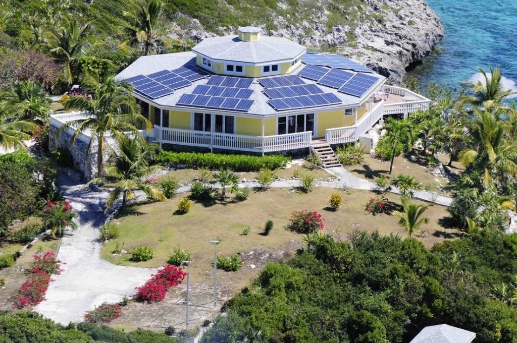
Expansion plans for the Solar shed include another 32 feet off to the west, using active panels/shingles, and a carport on the backside for golf cars and lawn mowers, using dead shingles. Now I am rethinking this. Maybe put the dead shingles on the south roof, because I have plenty of winter power, and live shingles on the north carport roof to capture the early and late rays. Maybe the guy whose house is featured in John’s Blog had the right idea.

Yeah, I like that idea, but what is immediately obvious is that solar modules are the wrong shape. They need to be in a keystone shape to maximize the panel area on the roof!
Of course, if you are ground mounted, you can use a tracker. These are available in single and dual axis form. They can be very expensive to buy and install, which raises the question: tracker or more panels? The big boys, who do enough of this stuff to know go both ways. It may just come down to available space. Most of the commercial farms that I have seen with trackers use a single-axis system. That just swings the array from east to west and should make a very big difference.
My own array makes plenty of power, but not necessarily when I need it. I could get by with a smaller pile of batteries, I suspect, if I could put more of that hot afternoon sun directly into my air conditioner instead of on the back of the shed!
This fall, I will be helping my friend Courtney with a new tracking array installation in North Carolina. Stay tuned for a report on the installation and the performance.
Now about that family that misplaced their cemetery, the bulk of them moved to Mississippi in 1836 after planting had depleted the soil here. John Sr. followed later, after Lucretia died. After depleting the soil at their Mississippi plantation, they moved to Texas and guess what? They forgot where they left the Mississippi cemetery, too! They are on their own finding that one.
–Neal

You have a ground penetrating radar!?…….envy…sounds like too much fun and, like my skidsteer…..oh you got one of those, how about doin’ a little work for me…(my answer: contribute to the trailer fund and I will be right over,note, I still don’t have a trailer).